
Beloreck - South Ural Mountains
<kuid2:354694:100247:24>
| Author: | OlegKhim |
| Kind: | map |
| Build: | 5.0 (TRS19 SP5) |
| Size: | 172.76MB |
| Uploaded: | 2023-04-14 |
| Website: | trainzup.com/ |
|
-
+
|
Beloreck - South Ural Mountains
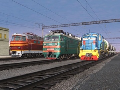
The route is an exact copy of the railways in the center of Eurasia, the Ural mountain range. The landscape, vegetation, profile of the railway track, the infrastructure of stations, cities and villages were recreated as accurately as possible. South Ural Railway is the initial link of Transsib - the longest railway in the world. The total length of the map is more than 250km, the railway is laid in the picturesque mountain areas of the Ural Reserve, which is located in the central, highest part of the Southern Urals. The highest point here is Mount Yamantau, whose height is 1639 m. Heavy profile, with a guiding incline of 18/1000, with a small radius of curves up to 300m, alternating current. The road connected Europe with Asia and allowed to carry important cargo and passengers.
From Magnitogorsk Beloretsk - South Ural railway, then Kuibyshev railway. At the station Inzer change the type of current.
Author: OlegKhim
- Beloreck - South Ural Mountains


User photos
No one has uploaded a photo of this object yet.
Comments:
Sign in to post a comment