1930s English Branchline - The Maritime Line (Truro to Falmouth)
<kuid:515942:100218>
| Author: | Robert3a0 |
| Kind: | map |
| Build: | 3.7 |
| Size: | 10.28MB |
| Uploaded: | 2025-11-22 |
| Downloads: |
12
-
+
|
1930s English Branchline - The Maritime Line (Truro to Falmouth)
The Maritime Line was built by the Cornwall Railway, a broad gauge railway 7 ft (2,134 mm) from Plymouth to Falmouth. The purpose of the scheme was to link London with Falmouth, a port where packet ships sailed to destinations in Europe, Africa, and America.
The section from Plymouth to Truro opened on 4 May 1859, and the inhabitants of Falmouth soon put pressure on the company to extend the line to their town as originally intended. The extension opened on 24 August 1863, by which time the packet ships had been diverted elsewhere.
After the West Cornwall Railway was converted to broad gauge in 1867, the Truro to Falmouth line tended to be operated as a branch, with the trains from London Paddington operating to Penzance instead.
The original stations on the line were at Truro, Perranwell (known as Perran until 19 February 1864), Penryn, and Falmouth (Now Falmouth Docks). Penmere was added on 1 July 1925.
The Cornwall Railway was amalgamated into the Great Western Railway on 1 July 1889. Following the amalgamation, plans were put in place for conversion to standard gauge, which took place over the weekend of 21 May 1892.
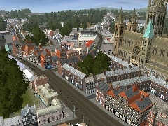
This Route commences in Truro and follows the branchline to Falmouth, as it would have been in the 1930's. The line branches at Penwithers Junction, with the left branch heading to Falmouth while the right branch continues the main line towards Helston.
The Falmouth branch handles passengers and freight, the latter mainly servicing the Falmouth Docks. The Route is suitable for adaption as a multi-player route.
I would like to acknowledge all the Content Creators whose content I have used in the construction of this Route - without your hard work and skill, this route would not have been possible. I would also like to thank all my colleagues from Trainz-Carriage-Works who have taken time out to Beta Test the Route and have advised me throughout its construction.
The Route was constructed using Google Earth as the key geographical reference. I was able to gather historic data on the Route from the Cornwall Railway Historic Society web page http://www.cornwallrailwaysociety.org.uk/falmouth-branch.html . Historic detail for the various station layouts and signalling arrangements was gathered from the web site, the Falmouth Signal Box http://www.s-r-s.org.uk/html/gwf/S1191.htm
This is freeware. The Route can be added too or altered with the proviso that any such changes acknowledge the original route Content Creator - robert3a0
- 1930s English Branchline - The Maritime Line (Truro to Falmouth)
- config.txt 161.85KB
- mapfile.bmk 330 bytes
- mapfile.gnd 7.32MB
- mapfile.lyr 23 bytes
- mapfile.obs 16.51MB
- mapfile.rlr 142 bytes
- mapfile.trc 14.10KB
- mapfile.trk 5.28MB
- thumbnail.jpg 61.07KB
User photos
No one has uploaded a photo of this object yet.
Comments:
Sign in to post a comment